


la grande Sure

dansanet
User
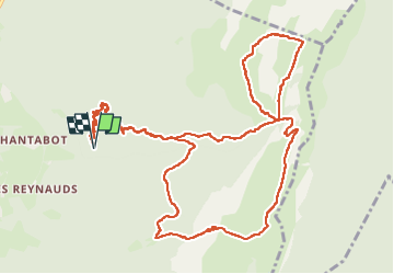

Length
15.8 km

Max alt
1904 m

Uphill gradient
1452 m
Km-Effort
35 km

Min alt
792 m

Downhill gradient
1451 m
Boucle
Yes
Creation date :
2025-07-06 06:47:33.007
Updated on :
2025-07-07 14:32:48.114
6h39
Difficulty : Difficult

FREE GPS app for hiking
 SityTrail
IGN / Geographical institutes
SityTrail Plus
The world is yours!
About
Trail Walking of 15.8 km to be discovered at Auvergne-Rhône-Alpes, Isère, La Sure en Chartreuse. This trail is proposed by dansanet.
Positioning
Country:
France
Region :
Auvergne-Rhône-Alpes
Department/Province :
Isère
Municipality :
La Sure en Chartreuse
Location:
Pommiers-la-Placette
Start:(Dec)
Start:(UTM)
709988 ; 5022612 (31T) N.
Comments